You’ve asked for it—and here it is.
Our 2026 comprehensive, boots-on-the-ground (& screen) plan for an incredible Tasmania Bay of Fires walk, all on your own steam. This 5-day Bay of Fires self-guided walk starts and ends at the same place, touches iconic landmarks, and steers clear of tour groups and pricey lodges. I wrote this after on the ground reconnaissance, digging deep online, mapping in AllTrails, and stitching together trip reports, and GPS data from other hikers. Why? Because Bay of Fires walking tours are expensive. Because I can’t find the info myself. And many of you have told me you want to go it alone, but don’t know how.
So here it is. A Bay of Fires multi-day hike for the ages. A proper loop walk that’s achievable, wild, and gorgeous. Designed for hikers who want to carry everything on their back, sleep in designated campgrounds, and end the walk exactly where they left the car. There are no private lodges, no boat drop-offs, and no daypacks waiting at camp. Just the trail, the tides, you and a few Forester Kangaroos, Bennetts Wallabies, and waddling wombats.
I’ve even stepped out the relevant Bay of Fires walking tracks in a map you can access on All Trails for free 👇🏽
Self guided 5-day Tasmania Bay of Fires walk: Overview
This Bay of Fires hike combines the coastal dreamscape of the Bay of Fires with the inland stillness of Mount William National Park, giving you two very different landscapes in one tidy loop. Each day clocks in under 15 km. You’ll walk along some of Tasmania’s most famous beaches, climb wukalina for panoramic views, cut through quiet inland bush, and camp beside lagoons, rivers, and dunes. It’s wild, it’s quiet, and it’s one of the most rewarding four-day hikes you can do in Tasmania.
It’s also an incredible way to do Bay of Fires on a budget. The only outlay during the trip is your $13 a night for the campsites. How else could you get an unforgettable Bay of Fires walk experience for under $60!
You will need to bring all your own gear, food and water. There are no huts like the 3 Capes or Overland Tracks. Just beach after beach, some pretty wild scrub and a big blue sea.

Is this Bay of Fires Walk Self-Guided Route Right for You?
So is this an easy, moderate or hard walk?
The full loop is roughly 50–60 km (31–37 mi) over four days of walking.
It’s moderate difficulty, there’s no climbing or scrambling. What you will face is longer distances each day made tougher by beach tracks. BUT! This hike is designed to minimise the pack you have to carry. Let me explain.
The walk returns to Deep Creek – where your car is parked – every second day. While you should carry 5 days worth of food, water and gear with you to Deep Creek, you only need to carry a single nights food and two days water on your hike, at any one time. The rest can stay locked in your car. The design is purposeful because there’s no reliable water on the trail. You’ll have to carry 3L/day with you. This can really add to the weight of your pack.
On this Bay of Fires walk, you’ll only need to carry a max of 6L at any one time. Plus food and your camp gear.
What about the terrain?
Its mostly flat beach walking with minor dune climbs and headland scrambles, rated by most hiking reports as easy to moderate. There are no major elevation gains except an optional side-trip up 216 m to the top of Mount William (wukalina).
Daily distances are 12–15 km, which on sand can be tiring – plan 5–7 hours walking per day depending on conditions.
Navigation is straightforward along beaches, but inland sections use sand tracks and 4WD/forestry trails, where a map/GPS is handy. This itinerary is deliberately looped to avoid much backtracking and also the cost of transport from one end of the trail back to your car – there is none up here.
There’s no fanfare on this Bay of Fires walk and that’s exactly what we’re after. Just the quiet promise of wild coast, sweeping views, orange rocks and wallaby tracks. We’re getting wild on these trails. If that’s the kind of fun you’re after, lets get to the good bit 👇🏽.
Where to Start & Finish this Tasmania Bay of Fires Walk
First, here’s the Bay of Fires walk map I mentioned earlier:
The trail head for this Bay of Fires Tasmania walk starts at Deep Creek Campground. But you’ll spend Day 1 getting there from either Launceston or St Helens.
Getting the Deep Creek Bay of Fires walking track is pretty straight forward, if you’re confident on remote roads. If you’re driving in from Launceston, give yourself plenty of time—and patience. Its a 2.5 hour drive. The fastest way is through Bridport along Highway B82. But its arguably more scenic if you take the A3 route via Scottsdale – you can even make a pit stop at the Little Blue Lake 👇🏽 which is phenomenal to see in the middle of nowhere.

If you’re driving from St Helens you can’t take the coastal route along Bay of Fires itself. That ends at The Gardens. Take Ansons Bay Road instead.
The closer you get to northern Bay of Fires, the more the roads tend to gravel, and become corrugated and pothole-riddled. These roads are remote – Zoe panicked the entire time driving out here because you don’t see anyone…… You don’t need a 4WD to get to Deep Creek. But also I don’t recommend renting a small car to save dollars if you’re doing this as part of a Tasmania fly-drive holiday. At least go for an SUV or AWD. You’ll feel safer for it.

Self Guided Bay of Fires Walk Itinerary
Launceston to Deep Creek Campground – Day 1
Your first day on this walk is spent getting to and then exploring Deep Creek at the northern end of Bay of Fires.
The Deep Creek camping area, which marks both the start and end of this loop, is tucked in the southern edge of Mount William National Park. There’s no transport here. Just a dusty access road off Ansons Bay Road, a self-registration box to put your $13 camp fee, and a patch of flat ground to leave your car.
There’s plenty of beaches to comb, swimming and relaxing to do though. If you’re heading in for a dip, check the beach first for these creatures 👇🏽. Their stings can be painful and it’s best to stay out range (although you won’t need medical treatment if you do get stung apparently).

Self Guided Bay of Fires Walk – Day 2
Deep Creek Campground to Stumpys Bay Campground #4
Distance: ~14–15 km (5–6 hours)
Route: Coastal beach walk with short rocky headlands
Overnight: Stumpys Bay Campground #4
Boots on, car locked, pack sorted, and the ocean to your right—it’s go time.
From Deep Creek Campground, head straight to the beach and walk north. Depending on the tide, you’ll either wade across the Deep Creek outlet or pick your way over a few rocks further inland. Plan to start early and aim for low tide if you want to keep your socks dry.
The tide is something you’ll want to watch closely as you pick your way up and down Bay of Fires during this hike.
The next few hours are pure east coast wilderness: long, untouched stretches of white sand, bursts of orange granite boulders, and not a phone tower in sight. The walking’s best close to the waterline where the sand’s firm. Higher up, it turns into a soft slog. Pace yourself. You’ll pass Picnic Rocks, Boulder Point, and Cod Bay—a string of secluded beaches and rocky headlands, each more photogenic than the last.

Navigation is simple on Day 2: hug the coastline. If you’re walking in spring, the inland dunes light up with wildflowers, and the birdlife is next-level. There are no trail markers here, but just keep the water on your right, follow the curve of the land and you’ll be fine. The final stretch cuts across Cod Bay, a long and beautiful arc of sand with almost zero human impact.
Near Cobler Rocks, take a short inland detour past a seasonal lagoon (a nice option if the tide’s high and the beach is narrow). Otherwise, press on and look for the path that leads inland to the day shelter and campsite at Stumpys Bay Campground #4.
Campground #4 sits tucked behind dunes and scrub just back from the beach. It’s the first of 4 campsites at Stumpys Bay. It’s basic, but peaceful. You’ll find a pit toilet, a couple of picnic tables, and maybe a fire pit. It’s worth a warning though. Some of these are ‘fuel stove only’ camp areas so don’t assume you can light a fire. Take a gas burner and follow the local signs. There’s a gas bbq in the picnic area nearby Campground 4 that you could use in a pinch or when there’s a Total Fire Ban.
There’s a self-registration system to camp: $13 per night for two people. This applies across Mt Williams National Park. Bring cash (its an envelope system). There’s no ranger here and no bookings. Just pick your spot and settle in. You’ll likely share the space with a few wallabies and some very determined possums (take small solid storage to protect your food).
Self Guided Bay of Fires Walk – Day 3
Stumpys Bay Campground 4 to Deep Creek (via Mount William inland trail)
Distance: ~16 km (6–7 hours)
Route: Inland heath, summit side-trip, and forested fire trails
Overnight: Deep Creek Campground
Today you head inland and swap the sea breeze for wildflowers, kangaroos, and a proper summit view.
Start by walking a short way back along the access road, head inland and look for the signposted track to Mount William / wukalina. Drop your pack if you like—the summit is about 2.5 km return, and the climb is gentle. At 216 metres it won’t push your lungs too hard, but the 360° views are well worth the effort. On a clear day, you’ll see the whole Bay of Fires coast and maybe even the Furneaux Islands out in Bass Strait.
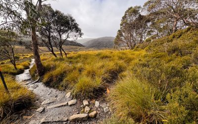
From the base of Mount William, continue south along Forester Kangaroo Drive, an old forestry trail that winds through dry coastal forest parallel to the beach. It’s flat and open with plenty of birdlife and a high chance of wildlife encounters. Forester kangaroos graze through here regularly, and if you’re lucky, you might see a wombat or even a Tasmanian devil cruise across the track.
Navigation is easy if you’re following a map or GPS. The trail turns toward Deep Creek as you head south. If you ever feel unsure, just head in a southeast direction and you’ll eventually hear the ocean again.
Second night you’re back at Deep Creek again. This is your chance to restock the food supplies, gear and water in your pack for the next two days of the hike.
Bay of Fires Multi-Day Hike – Day 3
Policeman’s Point to Deep Creek
Distance: ~15 km (5–6 hours)
Route: Inland gravel roads and coastal return
Overnight: Policeman’s Point Campground
This is your detour day. It’s not glamorous, but it’s essential—because you cannot walk across Ansons Bay. There is no pedestrian bridge across it. The only safe and legal crossing is via the causeway over Ansons River on the inland route. Attempting to cross the bay on foot is dangerous and not recommended.
So how do you get to the causeway? From Deep Creek, follow the path south to Eddystone Point – its a great viewing point with a cool lighthouse and you’ll stop here for a breather.
From Eddystone Point it’s time to head inland. It’s a long, gentle grind west along Eddystone Point Road and then Ansons Bay Road. After a few more km, you’ll reach a causeway over the Anson River.
Once across, look for Policeman’s Point Road, a sandy track that runs 5 km back east through eucalypt forest and heath. The walking’s quiet and unremarkable here. Keep an eye out for wedge-tailed eagles overhead and black cockatoos flapping lazily across the trees.
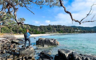
Eventually, you’ll break out of the bush and arrive at Policeman’s Point—a beautiful, calm estuary with distant views back to where you started. It’s peaceful, it’s undeveloped, and it feels like a reward after monotonous but beautiful bush.
Policeman’s Point Campground is one of the lesser-known gems in the Bay of Fires Conservation Area. There’s a compost toilet, decent flat ground, and a mix of shaded and open sites. No bookings, no treated water. You might spot a couple of campers or fishermen here, but it’s rarely busy. If you get in early, grab a site tucked into the coastal scrub on the southern side—more wind protection, better views.
As the light fades, wander down to the beach or estuary mouth and look across the water. That’s where you were on Day 1.

Self Guided Bay of Fires Walk – Day 4
Policeman’s Point Campground to Deep Creek Campground
Distance: ~15 km (6 hours)
Route: Beach walking up the coast
Finish: Deep Creek Campground
Final stretch. Another beach day. Pack your snacks and hit the sand.

From Policeman’s Point, backtrack until you reach N Ansons Road and use it head through the town of Ansons Bay. Keep following N Ansons Road until you come across a path to the right down to the beach. The walk from there to Eddystone Point is all coast. This is the iconic stuff: white sand, turquoise water, and lichen-covered boulders . You’re walking through the very heart of the Bay of Fires Conservation Area, and it’s a stunner. Watch the tides.
From Eddystone Point you’ll head back on the trail you came out on, towards your car at Deep Creek.
Bay of Fires Campsites Facilities & Conditions
All three campgrounds on this walk are bush basics—no showers, no phone signal, no bins. No drinking water. But they’re scenic, peaceful, and well worth carrying your gear into.
| Campground | Toilets | Water | Fires Permitted | Fees |
| Deep Creek | Pit | Bore (not drinkable) | Yes (in provided fire pits) | $13 per site/night |
| Stumpys Bay #4 | Pit | Seasonal tank (treat it) | Yes (in fire pits) | $13 per site/night |
| Policemans Point | Compost | None | Yes (in fire pits) | Free |
You’ll need a Tasmania Parks Pass for Mount William National Park too. No bookings are available for any of the sites. First in, best dressed.
Before any trip, check Parks & Wildlife alerts for track closures and Total Fire Bans—open fires aren’t allowed on those days, even in designated pits. Bring a fuel stove regardless. It’s lighter, safer, and allowed all year.
When to plan your self guided Bay of Fires walk
You can technically walk this loop any time of year, but if you want the best shot at good weather, go between October and April. That’s when you’ll get longer days, warmer water, fewer wet socks, and your best shot at dry gear and golden sunsets. That said, plan for any weather. Our photos are from the same week of December in two different years. You can see how different the weather is!


Summer (Dec–Feb) is peak season. Long daylight hours, warm nights, and ocean swims that won’t make you swear. It’s also the busiest—especially around Christmas and New Year. Get to camp early if you want your pick of the spots.
Autumn (Mar–May) is underrated. Quieter, cooler, and usually stable weather. It’s a great time to walk if you don’t mind packing a few extra layers. My favourite time of year in Tassie.
Spring (Sept–Nov) means wildflowers, active wildlife, and the odd moody sky. It’s still a great time to go—but expect wind and maybe a bit of rain. My least fave time of year.
Winter (Jun–Aug)? Doable, but chilly. Cold nights, wet trails, dramatic seas and no one else around. Good if you want solitude and don’t mind hiking in thermals. The camps can be exposed, and some inland sections get boggy. Go prepared with waterproof boots or don’t go at all.
Tasmania Bay of Fires Walk: What to Pack, Expect, & Avoid
Water
The most important thing to get right.
There is no treated drinking water anywhere along the loop. Deep Creek has a bore pump for washing (don’t drink it). Stumpys Bay might have a rainwater tank at the day shelter, but it’s unreliable. Creeks and lagoons are seasonal and tannin-stained. Don’t bet your walk on finding water out there.
You should carry 3–4L per person per day. That’s the safe baseline.
Navigation
This isn’t a technical route, but you still need to know where you’re going.
Personally, we use AllTrails when we’re out on the trials in Tasmania because getting lost when the weather changes here is flat-out dangerous. Also because you can download the maps and use them offline. Google directions to trailheads in Tassie are notoriously off.
If you’re double worried, pack a printed Tasmania Parks map as backup. Most of the route hugs the coast or follows clear inland tracks like Forester Kangaroo Drive. But inland junctions aren’t always signed, and beaches can get disorienting in poor weather.
You’ll have limited to no reception for most of the walk. Telstra has the best coverage here, but even then—don’t count on it.
Safety
You wanted a remote Bay of Fires self guided walk – you got it. But don’t forget that. Plan for it.
There are no rangers stationed at these camps. If something goes wrong, you could be hours from help. Carry a PLB (Personal Locator Beacon) or satellite communicator. Tell someone where you’re going and when you’ll be back.
There are snakes on this trail and accidents can happen. If they do, you’ll have an hour to get out and get to hospital. A PBL is your only hope. And I’m not kidding. Zoe almost stepped onto a Tiger Snake on a trail last time we were at Bay of Fires Conservation Area. And these trails on the northern Bay of Fires walking tracks are far wilder and less used by humans.
Overall, watch for snakes (tiger snakes here are of the top 10 deadliest variety), respect the tides, and don’t cross Ansons Bay on foot—ever. That’s how people end up in the news.
Final Word
This is one of the most rewarding self-guided multi-day hikes . It’s simple, it’s scenic, and it gets you off the beaten path without taking you entirely off-grid. You’ll walk some of the wildest stretches of beach in the country, climb a summit with panoramic views, sleep under the stars in quiet bush camps, and finish back at your car—tired, sandy, and better for it.
No porters. No fancy lodge meals. Just you, the trail, and four days of east coast wilderness. That’s the Tasmania Trails way (just don’t forget the trail snacks… ).
What’s next
- Heading to Bay of Fires? Read our ‘Beautiful Bay of Fires Guide‘.
- Find accommodation in St Helens for your Bay of Fires stay.
- If you’re heading down the East Coast, don’t miss our Epic East Coast Tasmania Guide and Great Eastern Drive roadtrip